


Developed by ACCA software, usBIM.geotwin advances openBIM®-GIS integration into...
SITEMAP

Geospatial Digital Twins: BIM-GIS Integration for cities, infrastructure, and territory
28.04.2026
Developed by ACCA software, usBIM.geotwin advances openBIM®-GIS integration into a dynamic, synchronized framework that delivers continuously updated data for the efficient management of cities, infrastructure, and territorial assets.
The evolution of information modelling is reshaping the AEC sector, driving the transition from isolated datasets to fully interoperable digital ecosystems. The integration of openBIM® and GIS, enabled by platforms such as usBIM.geotwin and ArcGIS, overcomes the limitations of traditional import/export workflows that historically produced static models with rapid data obsolescence, limited traceability, and reduced reliability.
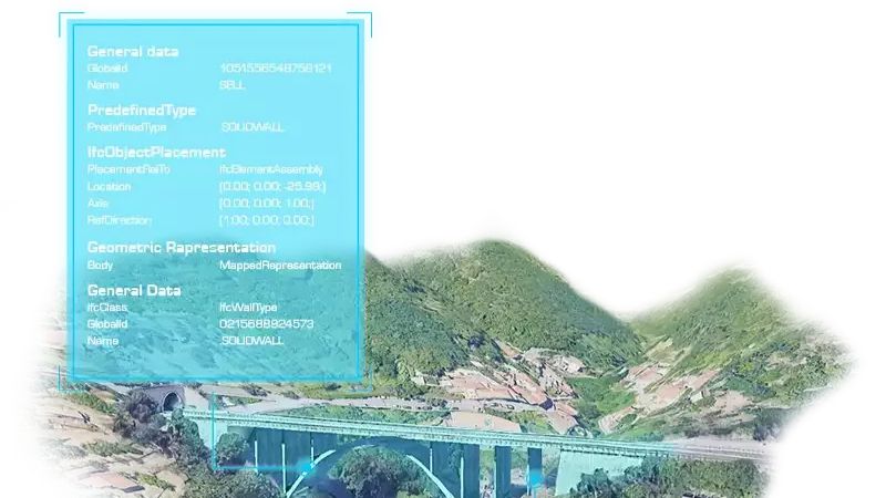
Geospatial digital twins introduce a more advanced operational paradigm in which data is continuously synchronized between BIM and GIS environments. Within this framework, the Common Data Environment (CDE) ensures consistency, governance, and accessibility of information throughout the asset lifecycle. Any geometric, alphanumeric, or structural modification is automatically captured and propagated across connected systems in real time, eliminating manual conversion processes and significantly reducing operational inefficiencies.
This integrated approach also addresses data scalability. Hundreds of federated models, millions of BIM objects, and extensive metadata sets can be managed across urban and regional contexts. GIS platforms therefore evolve into intelligent aggregation environments capable of combining BIM models, LiDAR point clouds, IoT sensor streams, and heterogeneous geospatial datasets into one reliable information ecosystem.
The practical applications are substantial. In transport and utility infrastructure, including roads, railways, bridges, viaducts, and energy networks, geospatial digital twins support predictive maintenance, asset performance optimisation, and Risk-Based Asset Management strategies. In the heritage sector, HBIM workflows enable the high-accuracy digital reconstruction of complex monuments while supporting long-term conservation planning and condition monitoring.
The convergence of BIM, GIS, and IoT further enables real-time structural health monitoring through continuous acquisition and analysis of sensor data. At metropolitan scale, initiatives such as the Roma Digital Twin demonstrate how integrated digital environments can enhance urban governance through scenario simulation, mobility analysis, service planning, and evidence-based decision-making.
Geospatial digital twins are therefore emerging as a strategic foundation for smarter, safer, and more sustainable asset and territory management.
News keywords Geospatial Digital Twins: BIM-GIS Integration for cities, infrastructure, and territory
Company news |

|
Geospatial Digital Twins: BIM-GIS Integration for cities, infrastructure, and territory
28.04.2026
|

|
Revit into an interoperable openBIM® platform with usBIM.revolution
Discover the advanced tool that transforms Revit into an integrated openBIM®... 30.03.2026
|

|
New Edificius release: smarter tools, faster workflows, and enhanced openBIM® performance
Discover Edificius: real-time collaboration, AI-powered design tools, upgraded... 23.02.2026
|


